Ruta de CabaÑeros: Un Viaje por su Naturaleza

¿QuÉ RUTAS PODEMOS HACER EN DESTINO CABAÑEROS?

Cabañeros National Park ofrece diversas formas de explorar su bosque mediterráneo: a pie, en bici o en vehículo todoterreno. Cuenta con 16 rutas de uso público, que puedes recorrer de forma libre o, en algunos casos, con guías intérpretes a través de la Central de Reservas. Además, hay empresas de turismo activo y ecoturismo acreditadas con la Carta Europea de Turismo Sostenible, con las que puedes reservar visitas privadas. Se recomienda combinar ambos tipos de rutas, ya que recorren distintas áreas del parque, brindándote una experiencia completa.

4X4 ROUTES

All-terrain routes allow you to make a more general visit and explore an area  more espacious. In this type of itinerary, that HE They also include a short walk to  foot and several observation stops. 

todoterreno

PUBLIC USE ITINERARIES OF THE NATIONAL PARK

  • Modality: free

  • Starting point: Torre de Abraham Visitor Center (Crta. CM-403, 10km from Pueblonuevo del Bullaque)

  • Duration: 45 min. (circular)

  • Length: 1 km (circular)

  • Difficulty: low

  • Accessible for people with reduced mobility.

It is a pleasant route on elevated walkways through the interior of a riverside forest next to the bed of the Bullaque River, surrounded by lush riverside vegetation and also typical vegetation of Mediterranean forests. It allows you to appreciate specimens of willow, ash, durillo, gall oak, etc., and enjoy the song of birds such as the nightingale or the wagtail. It has simple explanatory panels about the plants that are observed, and is accessible for people with reduced mobility.

Download self-guided brochure

  • Modality: free
  • Starting point: parking on the outskirts of the town of Horcajo de los Montes.
  • Duration: 1 hour. 30 min. (or 3 hours 30 minutes if you start from the town).
  • Length: 3.5 km. (circular)
  • Unevenness: 150m.
  • Difficulty: medium-low (it is recommended to wear appropriate footwear, as there are some rocky sections).

You reach the beginning of the route by taking a path that leaves the road that connects the towns of Horcajo and Alcoba. The path is marked by a green sign in both directions of the road (1 km from Horcajo). At the end of the dirt road you will find the parking lot and the beginning of the walking route. The route is marked with beacons.

Download self-guided brochure

  • Modality: Free or guided
  • Starting point: tourist information office in the town of Navas de Estena, if it is a guided tour, or in the parking lot on the route on the outskirts of the town
  • Duration: 3 hours 30 minutes from the town. 2 hours 15 minutes from the parking lot (round trip)
  • Length: 10 km from the town. 6 km from the parking lot (round trip)
  • Unevenness: 20m.
  • Difficulty: low (although it is recommended to wear appropriate footwear, as there are some small, somewhat rocky sections).

Attractive route that runs along the banks of the Estena River, a riverbed in a magnificent state of conservation. The itinerary is flat, and along the way you cross the river on a wooden bridge. In addition to a very beautiful landscape, you can enjoy the typical Mediterranean vegetation (with holm oaks, cork oaks, gall oaks, cistus, etc.), vegetation associated with the banks of the rivers (ash trees, willows, etc.), northern character like the yew or the birch, with curious geological shapes caused by erosion and traces from the times when this area was covered by the sea, more than 400 million years ago, like those of a giant marine worm. It is considered a Place of Geological Interest (Geosite).

Download self-guided brochure

  • Modality: Free or accompanied by a free guide-interpreter from the national park (only up to El Chorro).
  • Municipality: Los Navalucillos 
  • Starting point: information booth that is accessed by the track that leaves the KM. 16 of the CM-4155 highway
  • Duration (one way): 2 hrs. to Chorro, 2 hours. 45 min. to Chorrera Chica and 4 h. to Rocigalgo peak.
  • Length (one way): 4 km. to the Chorro; 5.5 km. to Chorrera Chica; 9 km. to Rocigalgo 
  • Accumulated drop: 200m. to Chorro, 300 m. to Chorrera Chica and 700 m. to Rocigalgo
  • Difficulty: medium (there are somewhat mountainous sections where you have to be careful and not go off the trail).

Download self-guided brochure

  • Modality: Free
  • Observations: The Park reserves the right to apply maximum capacity control on peak dates.
  • Starting point: information booth that is accessed by the track that leaves the KM. 16 of the CM-4155 highway.
  • Duration: 6 – 7 hours.
  • Length: 19 km. (circular linking with the Ruta del Chorro).
  • Unevenness: 950 m.
  • Difficulty: high

The information booth that marks the beginning of the route is accessed by taking a detour near kilometer point 16 of the CM-4155 highway, Las Becerras, approximately 10 km from Los Navalucillos. From this detour you will drive down a dirt track to the river, after which you will turn left to continue straight and, in about five minutes, reach the shed, where there is a small parking lot.

Download self-guided brochure

  • Modality: Free
  • Starting point: kilometer points 80 and 81 of the CM-4017 highway that connects Horcajo de los Montes and Retuerta del Bullaque.
  • Duration: 3 – 3:30 hours
  • Length: 13 km. (semicircular)
  • Unevenness: 150m.
  • Difficulty: moderate
  • Recommendations: good footwear, there are rocky sections

17 km from Horcajo de los Montes and 14 km from Retuerta del Bullaque, between kilometer points 80 and 81 of the CM-4017 highway that connects these two towns, there is a parking lot set up by the Park, which is the starting point.

Download Self-Guided Brochure

  • Modality: Free
  • Starting point: kilometer points 80 and 81 of the CM-4017 highway that connects Horcajo de los Montes and Retuerta del Bullaque.
  • Duration: 1 hour and 15 minutes round trip
  • Length: 4.6 km. (linear)
  • Unevenness: 150m.
  • Difficulty: moderate

17 km from Horcajo de los Montes and 14 km from Retuerta del Bullaque, between kilometer points 80 and 81 of the CM-4017 highway that connects these two towns, there is a parking lot set up by the Park, which is the starting point.

Download Self-Guided Brochure

  • Modality: Free (on foot or by mountain bike)
  • Starting point: Torre de Abraham or Casa Palillos Visitor Centers
  • Duration (one way): 3 hours.
  • Length (one way): 9.5 km.
  • Unevenness: 50m.
  • Difficulty: low (although in winter there are some sections that tend to become waterlogged)

The route links the Visitor Centers of Casa Palillos and the Torre de Abraham, so it can start at any of these two points, although if you are not going to do the entire route it is recommended to start at the Tower.

Download Self-Guided Brochure

  • Modality: Free
  • Duration: 30 min. (circular)
  • Length: 0.6 km (circular)
  • Without unevenness.
  • Difficulty: low.
  • Accessible for people with reduced mobility.

It is a flat path with interpretive panels about the most characteristic flora of Cabañeros. It is accessible for people with reduced mobility, and you can see most of the most abundant plants in the National Park.

Download self-guided brochure

  • Modality: Free.
  • Duration: 30 min. (circular)
  • Length: 0.8 km (circular)
  • Without unevenness.
  • Difficulty: low.
  • Accessible for people with reduced mobility.

It is a path with no slope with interpretive panels about the traditional uses of the inhabitants of the Cabañeros area. It consists of 7 explanatory stops about livestock farming, orchards (with a ferris wheel), traditional architecture (with typical cabins of the area), a bird's eye viewpoint, beekeeping, charcoal making and a threshing floor. It is accessible for people with reduced mobility.  

Download self-guided brochure

Modality: Free (on foot or by mountain bike).

Starting point: parking on the outskirts of the town of Horcajo de los Montes.

Duration: 2 hrs. 15 min. round trip (or 4 hours 30 minutes if you start from the town and circulate).

Length: 5 km. (round trip)

Unevenness: 85m.

Difficulty: low.

The route is near the town of Horcajo de los Montes. You reach the beginning of the route by taking a path that leaves the road that connects the towns of Horcajo and Alcoba. The path is marked by a green sign with the name of the route in both directions of the road (1 km from Horcajo). At the end of the dirt road you will find the parking lot and the beginning of the walking route. The route is marked with beacons.

Download self-guided brochure

  • Modality: Route with free guide-interpreter of the national park 
     
    Starting point:
     access gate to the Gargantilla public estate, which is accessed by a dirt track of about 3 km that leaves from kilometer point 37 of the CM-4157 highway (Navahermosa-Embalse del Cíjara).
  • Duration: 2 hrs. 30 min.
  • Length: 5 km (circular)
  • Unevenness: 100m.
  • Difficulty: low.
  • Recommendations: Comfortable clothing and footwear during the visit. Bring food and water, as this route is very far from urban centers.

This route is a short but very interesting variant of the Alcornocal Valley route, so both itineraries have similar characteristics.

Download self-guided brochure

  • Modality: Route with free guide-interpreter of the national park 
  • Starting point: access gate to the Gargantilla public estate, which is accessed by a dirt track of about 3 km that leaves from kilometer point 37 of the CM-4157 highway (Navahermosa-Embalse del Cíjara).
  • Duration: 4 hours (circular)
  • Length: 6.5 km (circular)
  • Unevenness: 300m. Difficulty: medium-low (there is a section with quite a slope that is not recommended during very hot times and hours)
  • Recommendations: Comfortable clothing and footwear during the visit. Bring food and water, as this route is very far from urban centers.

There are very good panoramic views, crossing Mediterranean forests and descending to the beautiful banks of the Estena River and the Valhondo stream.

Download self-guided brochure

  • Modality: Route with free guide-interpreter of the national park 

    Starting point: access gate to the Gargantilla public estate, which is accessed by a dirt track of about 3 km that leaves from kilometer point 37 of the CM-4157 highway (Navahermosa-Embalse del Cíjara).

    Duration: 4 hours (circular)

    Length: 10 km (circular)

    Unevenness: 150m.

    Difficulty: low.

    Recommendations: Comfortable clothing and footwear during the visit. Bring food and water, as this route is very far from urban centers.

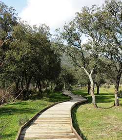
    The route runs through a pleasant valley with oak forests and cork oaks, and along the way, in addition to enjoying panoramic views of the Mountains, we find a pond on the banks of which it is easy to see different amphibians.
    Download self-guided brochure

  • Modality: Free
  • Starting point: Navas de Estena town or Recreational Area parking
  • Duration: 3 hrs. from the town, 1 hour. 15 min. from the parking lot (round trip)
  • Length: 7 km. from the town, 3 km. from the parking lot (round trip)
  • Unevenness: 10m.
  • Difficulty: low

    Cabañeros: Acebo and Las Fuentes Recreational Area Trail Route

    • Ruta Camino del Área Recretativa del Acebo y de las Fuentes

      Modality: Free

      Starting point: Navas de Estena town or Recreational Area parking

      Duration: 3 hrs. from the town, 1 hour. 15 min. from the parking lot (round trip)

      Length: 7 km. from the town, 3 km. from the parking lot (round trip)

      Unevenness: 10m.

      Difficulty: low

      The path, with a flat layout, begins in the Tabla del Acebo Recreational Area, 2 km away. from the town of Navas de Estena, from where you can also start.

      Download self-guided brochure

  • Mode: Free
  • Observations: The Park reserves the right to apply maximum capacity control on peak dates.
  • Starting point: information booth on the borders of the National Park (Los Navalucillos).
  • Duration: 1 hour (round trip)
  • Length: 2 km. (round trip)
  • Unevenness: 75m.
  • Difficulty: low

The information booth that marks the beginning of the route is accessed by taking a detour near kilometer point 16 of the CM-4155 highway, Las Becerras, approximately 10 km from Los Navalucillos. From this detour you will drive down a dirt track to the river, after which you will turn left to continue straight and, in about five minutes, reach the shed, where there is a small parking lot.

Download self-guided brochure

en_GBEnglish (UK)

Guía de Rutas a Pie en Cabañeros

No hay mejor forma de descubrir la riqueza natural del Parque Nacional de Cabañeros que a través de sus itinerarios a pie. Este espacio único en España invita a los visitantes a explorar su biodiversidad mediante diversas rutas, pensadas para diferentes niveles de habilidad y accesibilidad. Realizar una ruta en Cabañeros permite conectar con la naturaleza en su estado más puro, en un entorno privilegiado donde flora y fauna conviven en armonía.

El Parque Nacional de Cabañeros cuenta con una amplia variedad de rutas a pie, que van desde sencillos senderos botánicos hasta recorridos más largos y exigentes. Algunas de estas rutas pueden realizarse de manera libre, mientras que otras ofrecen la posibilidad de ser guiadas por expertos en interpretación ambiental. Estas rutas guiadas, gratuitas, requieren reserva previa en el Centro Administrativo del parque y proporcionan una experiencia enriquecedora, pues los guías ayudan a comprender el valor ecológico de cada rincón del parque.

Antes de iniciar cualquier ruta en Cabañeros, se recomienda pasar por uno de los centros de información del parque. Estos centros no solo brindan mapas y detalles de las rutas disponibles, sino que también orientan a los visitantes sobre cómo contribuir a la conservación del espacio natural. Respetar las normas de visita y mantener una actitud cuidadosa es fundamental para asegurar que todos puedan disfrutar de la belleza de Cabañeros sin perjudicar su delicado ecosistema.

Entre las rutas del Parque Nacional de Cabañeros, encontramos opciones para todos los gustos y niveles de habilidad. Los senderos están diseñados para que cada visitante pueda explorar a su propio ritmo, disfrutando de los diferentes paisajes que ofrece el parque, como la Raña de Santiago, una gran llanura donde se pueden avistar ciervos, especialmente en la época de la berrea.

Para quienes buscan un recorrido sencillo, el parque ofrece rutas cortas, como la Senda de la Torre de Abraham. Este recorrido circular de apenas 1 km y dificultad baja es perfecto para un primer contacto con la flora autóctona, donde se destacan los usos tradicionales de las plantas en la cultura local. Por otro lado, si prefieres un itinerario de mayor longitud, puedes optar por el sendero del Boquerón del Estena, una ruta de baja dificultad de hasta 10 km en la que es posible observar icnofósiles, huellas fósiles de organismos antiguos que vivieron hace millones de años.

Para los senderistas más experimentados, el parque cuenta con rutas exigentes como la del Macizo del Rocigalgo, el punto más alto de Cabañeros. Este itinerario de alta dificultad permite explorar la diversidad geológica del parque mientras se disfruta de espectaculares vistas panorámicas desde la cima.

Realizar un itinerario a pie en el Parque Nacional de Cabañeros con un guía-intérprete ofrece una perspectiva única sobre el valor de este entorno protegido. Los guías no solo acompañan a los visitantes a través de los senderos, sino que también proporcionan explicaciones detalladas sobre la flora, fauna y geología del parque. Estas rutas guiadas son gratuitas, pero debido a su popularidad, se recomienda reservar con anticipación llamando al Centro Administrativo del parque.

Entre las rutas guiadas, una de las más interesantes es la ruta del Robledal-Alcornocal, que recorre un bosque mixto de robles y alcornoques, ofreciendo la oportunidad de observar aves rapaces y otras especies en su hábitat natural. Otra ruta destacada es la de Valhondo, de 6.5 km y dificultad media, ideal para quienes buscan un recorrido completo que atraviese diferentes ecosistemas.

  • Planifica tu visita: Antes de realizar cualquier itinerario, visita los puntos de información del parque para conocer el estado de las rutas y recibir recomendaciones.
  • Lleva equipo adecuado: Aunque algunas rutas son de baja dificultad, es fundamental llevar calzado de senderismo y ropa cómoda, además de agua y comida, especialmente en los recorridos más largos.
  • Respeta el entorno: Mantén una actitud respetuosa hacia el medio ambiente, evitando salir de los senderos marcados y no molestando a la fauna.
  • Consulta el clima: En épocas de calor, algunas rutas pueden volverse exigentes debido a la falta de sombra. Planificar las caminatas en las primeras horas de la mañana o al atardecer te ayudará a evitar temperaturas extremas.

Cada estación del año ofrece una experiencia diferente en el Parque Nacional de Cabañeros. En primavera, el parque se viste de colores vibrantes, con el florecimiento de múltiples especies de plantas autóctonas. El otoño, en cambio, es famoso por la berrea de los ciervos, un espectáculo natural donde los machos emiten potentes bramidos para atraer a las hembras. Durante esta época, las llanuras y los montes de Cabañeros se llenan de vida y sonido, convirtiendo el senderismo en una experiencia inolvidable.

El verano puede ser caluroso en algunas zonas del parque, pero con las rutas de menor duración y planificación adecuada, es posible disfrutar de itinerarios matutinos o al atardecer. En invierno, las rutas también son accesibles, y la tranquilidad del parque en esta estación brinda una sensación de aislamiento y serenidad que muchos visitantes aprecian.

The rutas de senderismo en el Parque Nacional de Cabañeros permiten a los visitantes conocer la riqueza de este paraje natural y vivir la naturaleza en su máxima expresión. Desde itinerarios cortos para familias hasta senderos desafiantes para los más experimentados, cada ruta brinda la oportunidad de explorar paisajes únicos y observar la biodiversidad que hace de Cabañeros un lugar excepcional. Te invitamos a descubrir las diferentes rutas disponibles y a disfrutar de un itinerario a pie en Cabañeros que se adapte a tu nivel y preferencias. Sumérgete en la belleza de este parque nacional y contribuye a su conservación mientras te aventuras por sus caminos.

Destino Cabañeros
Privacy Overview

This website uses cookies so that we can provide you with the best user experience possible. Cookie information is stored in your browser and performs functions such as recognising you when you return to our website and helping our team to understand which sections of the website you find most interesting and useful.