

Modality: free
Starting point: Torre de Abraham Visitor Center (Crta. CM-403, 10km from Pueblonuevo del Bullaque)
Duration: 45 min. (circular)
Length: 1 km (circular)
Difficulty: low
Accessible for people with reduced mobility.
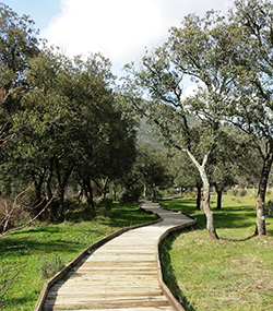
It is a pleasant route on elevated walkways through the interior of a riverside forest next to the bed of the Bullaque River, surrounded by lush riverside vegetation and also typical vegetation of Mediterranean forests. It allows you to appreciate specimens of willow, ash, durillo, gall oak, etc., and enjoy the song of birds such as the nightingale or the wagtail. It has simple explanatory panels about the plants that are observed, and is accessible for people with reduced mobility.
You reach the beginning of the route by taking a path that leaves the road that connects the towns of Horcajo and Alcoba. The path is marked by a green sign in both directions of the road (1 km from Horcajo). At the end of the dirt road you will find the parking lot and the beginning of the walking route. The route is marked with beacons.
Attractive route that runs along the banks of the Estena River, a riverbed in a magnificent state of conservation. The itinerary is flat, and along the way you cross the river on a wooden bridge. In addition to a very beautiful landscape, you can enjoy the typical Mediterranean vegetation (with holm oaks, cork oaks, gall oaks, cistus, etc.), vegetation associated with the banks of the rivers (ash trees, willows, etc.), northern character like the yew or the birch, with curious geological shapes caused by erosion and traces from the times when this area was covered by the sea, more than 400 million years ago, like those of a giant marine worm. It is considered a Place of Geological Interest (Geosite).

The information booth that marks the beginning of the route is accessed by taking a detour near kilometer point 16 of the CM-4155 highway, Las Becerras, approximately 10 km from Los Navalucillos. From this detour you will drive down a dirt track to the river, after which you will turn left to continue straight and, in about five minutes, reach the shed, where there is a small parking lot.
17 km from Horcajo de los Montes and 14 km from Retuerta del Bullaque, between kilometer points 80 and 81 of the CM-4017 highway that connects these two towns, there is a parking lot set up by the Park, which is the starting point.
17 km from Horcajo de los Montes and 14 km from Retuerta del Bullaque, between kilometer points 80 and 81 of the CM-4017 highway that connects these two towns, there is a parking lot set up by the Park, which is the starting point.
The route links the Visitor Centers of Casa Palillos and the Torre de Abraham, so it can start at any of these two points, although if you are not going to do the entire route it is recommended to start at the Tower.
It is a flat path with interpretive panels about the most characteristic flora of Cabañeros. It is accessible for people with reduced mobility, and you can see most of the most abundant plants in the National Park.
It is a path with no slope with interpretive panels about the traditional uses of the inhabitants of the Cabañeros area. It consists of 7 explanatory stops about livestock farming, orchards (with a ferris wheel), traditional architecture (with typical cabins of the area), a bird's eye viewpoint, beekeeping, charcoal making and a threshing floor. It is accessible for people with reduced mobility.
Modality: Free (on foot or by mountain bike).
Starting point: parking on the outskirts of the town of Horcajo de los Montes.
Duration: 2 hrs. 15 min. round trip (or 4 hours 30 minutes if you start from the town and circulate).
Length: 5 km. (round trip)
Unevenness: 85m.
Difficulty: low.
The route is near the town of Horcajo de los Montes. You reach the beginning of the route by taking a path that leaves the road that connects the towns of Horcajo and Alcoba. The path is marked by a green sign with the name of the route in both directions of the road (1 km from Horcajo). At the end of the dirt road you will find the parking lot and the beginning of the walking route. The route is marked with beacons.
This route is a short but very interesting variant of the Alcornocal Valley route, so both itineraries have similar characteristics.
There are very good panoramic views, crossing Mediterranean forests and descending to the beautiful banks of the Estena River and the Valhondo stream.
Modality: Route with free guide-interpreter of the national park
Starting point: access gate to the Gargantilla public estate, which is accessed by a dirt track of about 3 km that leaves from kilometer point 37 of the CM-4157 highway (Navahermosa-Embalse del Cíjara).
Duration: 4 hours (circular)
Length: 10 km (circular)
Unevenness: 150m.
Difficulty: low.
Recommendations: Comfortable clothing and footwear during the visit. Bring food and water, as this route is very far from urban centers.
The route runs through a pleasant valley with oak forests and cork oaks, and along the way, in addition to enjoying panoramic views of the Mountains, we find a pond on the banks of which it is easy to see different amphibians.
Modality: Free
Starting point: Navas de Estena town or Recreational Area parking
Duration: 3 hrs. from the town, 1 hour. 15 min. from the parking lot (round trip)
Length: 7 km. from the town, 3 km. from the parking lot (round trip)
Unevenness: 10m.
Difficulty: low
The path, with a flat layout, begins in the Tabla del Acebo Recreational Area, 2 km away. from the town of Navas de Estena, from where you can also start.
The information booth that marks the beginning of the route is accessed by taking a detour near kilometer point 16 of the CM-4155 highway, Las Becerras, approximately 10 km from Los Navalucillos. From this detour you will drive down a dirt track to the river, after which you will turn left to continue straight and, in about five minutes, reach the shed, where there is a small parking lot.


 English (UK)
  Español